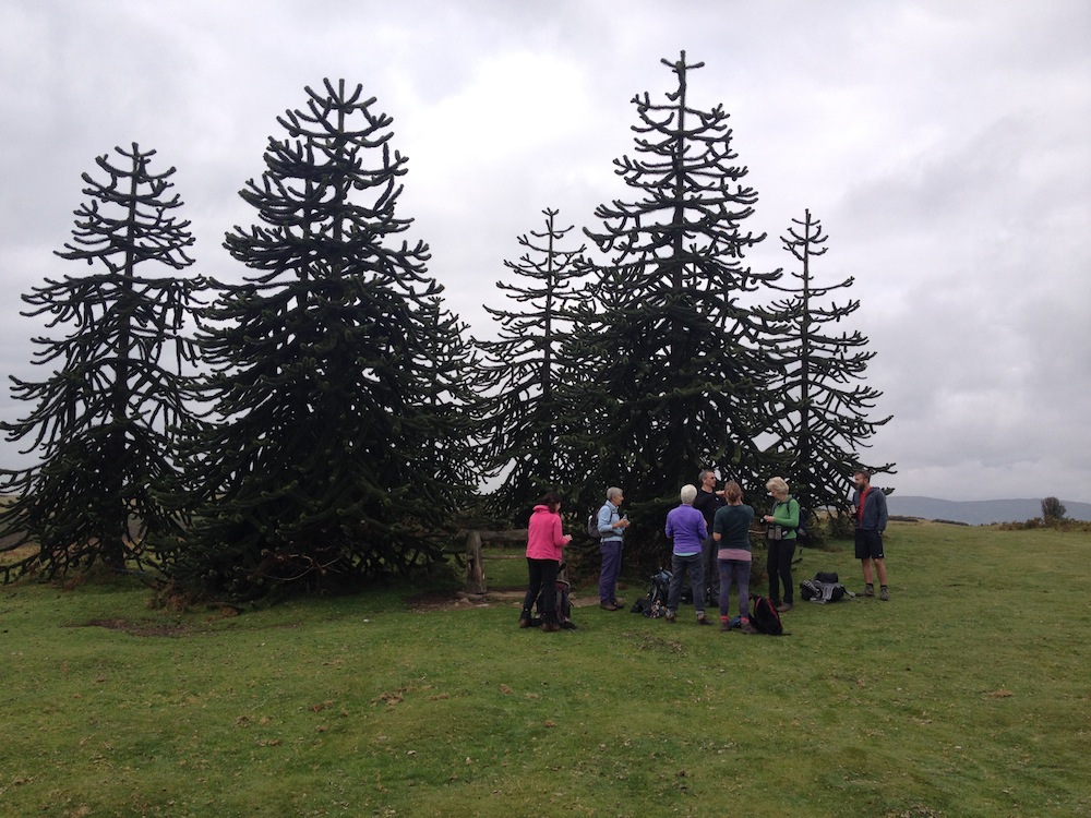
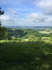
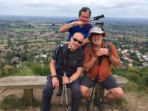
David Thomas, Simon Davis and I set off early on the 26th June to travel to Broadway and Creampots Camp Site, just a couple of miles inland from Broad Haven. Our objective was to set up camp prior to the rest of the group arriving. After all, I had advertised that by the time they arrive, the kettle would be on, the wine chilled and the dinner cooking. So, having lunched at the Galleon, a rather seedy looking pub that served good food, in Broad Haven, we set about the task of setting up camp. We had the whole, substantial field to ourselves, allowing us to spread out enough to satisfy Ros, our characterful campsite owner, and the fire regulation of placing the tents at least three metres apart. The conditions were perfect and, true to my word, camp was set up and all those bold statements in the advertising material were in place by the time the group arrived. We were not a large group, just eight in total but growing to nine by midweek. That night we ate a lovely beef goulash and celebrated Sandy Davis’ birthday with bubbly and cake, although the breeze meant that it was impossible to light the zillions of candles.
A damp start
During the night rain drummed on the taught canvass of our tents, promising us at least a wet start to our Pembrokeshire Coast Path journey. It was still raining, not too heavily, as we drove to Newport, the starting point of the walk. It was sufficiently wet to have to don our waterproofs, to protect us from the wet vegetation on either side of the narrow path as much as anything. As we left Newport, with light rain still falling, we were approached by a local in shorts and wellies returning from a dog walk. As he passed he advised that we would have been better staying in bed. But he was wrong. Within an hour the rain had stopped, the clouds began to break up and the sun shone. Waterproofs were bundled, damp, into our rucksacks and we enjoyed pleasant walking conditions, sunshine, not too hot with a cooling sea breeze, for the rest of the day.
In places the path was very narrow and in need of a little maintenance to cut back the encroaching vegetation. For much of the time we were walking along a narrow channel, not quite wide enough to walk properly along and causing us to have to concentrate on each foot placement. The route was also very up and down, none of them being excessively long but collectively energy sapping. The steeper parts were stepped, not evenly, but with a varied drop, some of which were excessively high and particularly difficult when going down. It was hard to get a proper rhythm on them.
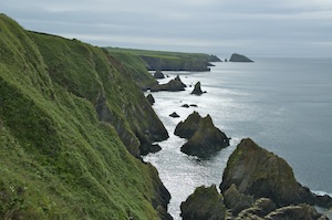
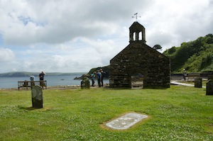 The coastline was dramatic throughout but I was particularly looking forward to walking around Dinas Head. It bulges out into the sea from a relatively narrow neck and is often referred to as Dinas Island. It is approached from the north via Cwm-yr-Eglwys (Valley of the Church). Following storms in 1850 and 1851the church was seriously damaged. The graveyard was breached by the sea and human remains began to appear. Another storm in 1859 rendered the church unusable and it was immediately abandoned. The sea continued to claim the church until all but west end was demolished in 1880. The sea continued to attack the remains and the graveyard, and, after a storm in 1979, a new sea wall was built to protect what was left. For us it was an attractive resting place. The sea was a placid as it could possibly be and it is hard to imagine the force that was necessary to do such devastating damage to a solidly built church.
Dinas Head
The east side of Dinas Head is protected from the prevailing winds allowing for a much wider variety of plants and trees to grow. The flowers that lined the way were in full bloom, something we saw throughout our journey along the coast path, and their perfume filled the air, particularly so on this this morning after being freshened up by the rain. Sheltered from the wind, it was much warmer travelling up to Pen y Fan (top of the hill) and the heat emanating from the vegetation was stifling at times.
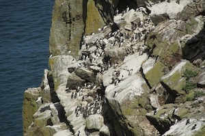
A colony of guillemots
It wasn’t just plants that thrived on this sheltered side of Dinas Head, birds also. Stacks, now separated from the mainland, were safe havens for colonies of sea birds. Guillemots crowded on to precariously sloping ledges, jostling for position and producing a cacophony of noise. We were fascinated as to why some stacks were heavily populated while others were devoid of any bird life at all. I think there may be a number of factors which determine which stacks, cliffs and rocks are favourable to colonisation. Shelter from the elements must be a major influence. I also think the type, texture and angle of the rocks is important, accessibility to a reliable food source and protection from predators.
On reaching the top of the headland the wind was in our faces again and it was much fresher, and continued to be so all the way down the western side of the headland. The vegetation was much more limited, with largely grasses and brackens and no trees. The few trees that could withstand the elements were stunted and severely shaped by the prevailing winds.
Back on the north coast we looked out into Fishguard Bay and along the coast to Fishguard, and Goodwick from which the ferry now left for its crossing to Rosslare in Ireland. Stopping at Penrhyn Campsite we enjoyed a refreshing ice cream before completing the final leg of our day’s walk. It was warm and very sunny, stark contrast to the conditions we set out in, and the ups and downs were beginning to take their toll on our legs.
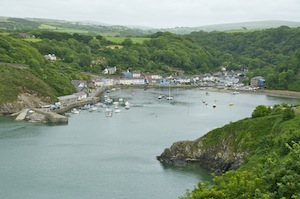
Lower Town
Passing through the attractive Lower Town, we followed the coast round, missing much of Fishguard and meeting Angela who walked to meet us. Finally we reached our designated finish point and while Angela took David and John back to Newport to collect their cars the rest of us contemplated a drink. Seeing brown signs for the Ferry Boat Inn, we followed their direction, inland for quarter of a mile. On arrival we discovered it had changed from being an inn to a b&b with no bar! Trudging back to the finish point we popped into Tesco and bought bottles of beer having been confidently informed by Claire that she had a bottle opener. Salivating, we waited while she rummaged in her rucksack to produce her credit card size Swiss Army Knife, not with a bottle opener but with a pair of scissors. Desperation, or was it experience, enabled us to remove the caps and savour the nectar within, while we waited for our lift back to camp.
Although I had tweaked the itinerary in order to make the days more even, the second day was always going to be a tough one. Even with the new finish at Abercastle, we were still going to walk in excess of 16 miles with over 4,000 feet of ascent. At least the weather was in our favour. While the rest of the country was entering a heatwave that would see the highest July temperatures on record, we were blessed with sea breezes which kept temperatures down to a maximum of the low 20s. Stella, had a foot issue and, having only walked a few steps, decided not walk but to keep Angela company for the day.
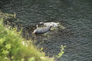 Zig-zagging our way through woodland, we climbed out of Goodwick to join the clifftop path which hugged the line of the coastal cliffs. The scenery was, again, spectacular with stacks and arches adding to the interest. Also adding to the interest were our first sightings of seals basking on rocks and playing together in the water. We heard them before we saw them, their deep, guttural barks alerting us to their presence. Despite the fact that we were 120 feet above them, they knew we were there and played to their audience, gamboling and rolling in the water, or simply treading water so they could see us more easily.
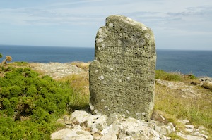 Dropping yet again to sea level we climbed back up through cooling woodland back to the clifftop and a memorial stone at Carreg Goffa, to mark the place where the last invasion of mainland Britain took place at Carregwastad Point on 22nd February 1797. The invasion by 1200 French soldiers, led by Colonel William Tate, an Irish American, resulted in the Battle of Fishguard. The invaders saw little success and surrendered three days later.
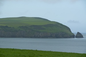
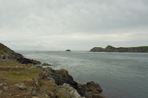
 Following the coast we reached Strumble Head in time for lunch, sitting a short distance from the lighthouse flashing its powerful light as a warning to any passing ships. I was looking forward to rounding this headland as it would mean we would not be able to see Dinas Head again and that we were making progress. The coast was now at its most spectacular with some beautiful, inaccessible coves, dramatic cliffs and many jagged stacks constantly lapped by the sea. I couldn’t help feel how dramatic it would look in a storm.
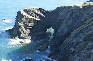
Dramatic coastal scenery
The heat was beginning to take its toll and we were beginning to run out of water so we sent a message to Angela to meet us where a lane came down to meet the coast path and to bring water and other refreshments to give us a boost. It was so welcome. Claire, having stopped for a break, decided to call it a day and forgo the last three miles or so in favour of staying with Angela in the car.
Angela, Stella and Claire walked towards us as we approached Abercastle and the refreshments Angela gave us at the finish were unexpected but most welcome. While some went off to get the other car from the start, the remainder of us enjoyed some good beer and this time we did have a bottle opener!
We had now completed, probably, the two most arduous days of the trek. Day three was another beautiful day and while temperatures soured even higher in other parts of the UK, here they remained comfortable. The walk involved less up and down and had long stretches of relatively flat, clifftop walking. We were back to a full compliment of walkers.
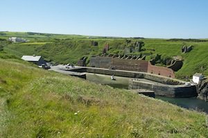
Porth-gain’s industrial past
Leaving Abercastle, we continued westwards, bypassing Trefin and eventually came upon Porth-gain with its rich, but short, industrial past. Porth-gain harbour was used for almost one hundred years, until 1931 for the export of roadstone, slates and bricks. Alongside the harbour are the remains of the old brick works and the massive bins that held the crushed stone. Now it is quite a smart village with some of the old industrial buildings converted into smart restaurants and curio shops. We took advantage of the facilities to rehydrate and eat local ice cream.
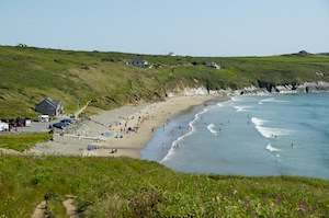
Whitesands Bay
St David’s Head was getting ever closer. Looking back the way we had come we could again see the winking eye of Strumble Head lighthouse, now more than twenty miles away. The coast here was less indented and the inland scenery more interesting with the hills of Carnedd lleithr, Carn Llidi and Carn Hen rising to their impressive rocky outcrops. Rounding the headland we could see Whitesands Bay and the expansive beach that attracts many holiday makers on a good day. It is a bit of a Mecca for surfers, being exposed to the Atlantic swell and the opportunities that gives for riding the waves. Today there was little swell but it provided excellent conditions for novices to hone their skills.
It proved quite warm throughout the day and I had been dreaming of having a swim when we reached Whitesands. Going on to the beach, we released our feet from the confines of our boots and wandered down to the water’s edge. We did not go far and any thoughts of having a swim were quickly dispelled. The sea was not warm. This was confirmed when you took time to observe those that were in the sea, were all wearing wet suits.
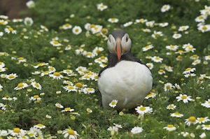
After three days of walking we deserved a rest day so I arranged for the group to take the boat from Martin’s Haven for the short crossing to Skomer Island. Thankfully it was only a short crossing as I don’t think Simon would have been able to keep his breakfast had it been much longer. You only had to look at him to realise he was concentrating hard.
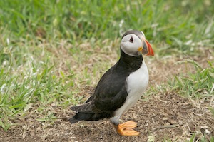 In parts of Britain this day was the hottest July day on record with temperatures above the mid thirties. On Skomer, we started out in sunshine but after only an hour there the sea mist rolled in and temperatures were suppressed. Although we could not see much of the cliff colonies and there was no chance of seeing seals, porpoises and dolphins we had such a wonderful time enjoying the clown-like antics of the puffins. Not only do they look like clowns, they act like them. They are such delightfully innocent birds and I could spend hours watching and enjoying their company. They seem to have little fear amongst humans, which makes them all the more attractive.
 It was a calm day but the unseen noise of the sea on the exposed side of the island suggested that it was quite rough. I wish I could have seen it. I would love to see it during stormy conditions. I imagine it being a very dramatic place to be in a storm. I certainly want to go back and spend a night or two on the island, enjoying the birds after most of the tourists have gone home. Then we might be able to see something of the 316,000 Manx Shearwaters that emerge from their burrows at night.
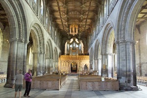 Before heading to Whitesands Bay for the resumption of our walk we spent a little time in St David’s, taking time to visit the cathedral. It is unique as a cathedral as it is build in a hollow and cannot be seen until you actually stand on the edge of the hollow, almost level with the top of the tower. Most cathedrals are built in prominent positions where they can be seen from some distance. At least, being built where it is, it is protected from the strong winds coming off the Atlantic. I have been to the cathedral a number of times but I don’t remember the pronounced slope of the nave, nor the angle of the supporting pillars either side of it. They lean out at quite a sharp angle.
The western end of the peninsula around St David’s was far less indented and good progress could be made. At St Justinians, path diversion signs redirected us around the construction of a new lifeboat station.
Ramsey Sound
Our interest was now drawn to Ramsey Island, or more precisely to the stretch of water between it and the mainland. This stretch, where the tidal currents are squeezed, is renowned for its choppy water and strong currents. The rocks that jut out from the island at its narrowest point and adds spice to the flow are known as the Bitches of Ramsey Sound. We watched a launch make little progress against the flow despite having the engine running at full throttle. Suddenly, having fought its way through it is released by the currents and shoots forward.
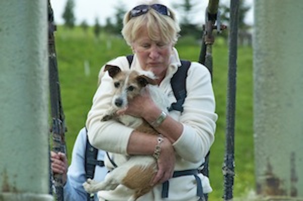
At one point, just ahead of us we saw somebody take a tumble. Rushing to their aid we discovered an old lady half lying, half sitting uncomfortably among the rocks. I think what had happened was that she looked up when she saw us and lost her footing. Although she had not broken the skin she had raked her shin over a rock and her knees were also showing signs of bruising. Sending the rest of the group ahead to wait for us, David and I patched her up, made sure she had food and drink, and that she was not suffering from shock. She was very chatty and as I eventually helped her up to negotiate the rest of the rocky slope I asked her how old she was. Pauline was 81 and was on holiday from Leeds, walking the coast path and staying at youth hostels. What a game old bird. We watched her as she continued in her sprightly manner and then spoke to another female walker going in her direction to just keep an eye on her.
 It had been the tendency throughout this walking week to have two lunch stops. Today was no exception and as we sat on a grassy bank at the side of the path, enjoying the sunshine and the opportunity to rest, we were joined, at first by one gull, waiting in the hope that we might throw it some scraps. Doing so, we were then joined by several other gulls who then proceeded to give us a fantastic aerial display as they jostled for food and position. It gave us an opportunity for some great action photos.
This southern section of the headland was again more indented, not with wide sweeping bays but with narrow inlets. It was to the largest of these inlets that we were heading for at Solva, a quaint village at the top of the inlet. Here, as it was my birthday, we relaxed at the pub, sitting in the sunshine, while waiting for our lifts to materialise. There was no rush, we had made reasonably good time and we had a good reason to stay for a drink or two.
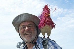
Me and my cockerel!
In the evening I was presented with my rucksack with a rear view mirror attached so that I could keep an eye on the group behind me, and a horn! I later found a former shop display cockerel in my sleeping bag, which I was instructed to wear on my shoulder for the next day’s walk. This created some fun on the walk as we would meet people who would look at me and not notice the cockerel. David would ask people who had just passed me if they had seen a man with a cockerel on his shoulder. They would look blankly and say ‘no’ to then have me pointed out. One man did say that he hadn’t seen a man with a cockerel on his shoulder but seen a cockerel with a man up its arse! When people did notice, they demanded an explanation.
Stonechat
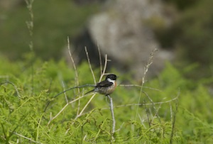
It was quite a long walk today all along the edge of St Bride’s Bay from Solva to St Brides. It was also a varied walk with fantastic clifftop stretches, long beaches at Newgale and Broadhaven. Throughout the walk we had been attracted to the wildlife, the occasional sightings of seals, the gulls soaring on thermal currents of air, the dogfights between peregrine falcons and gulls, kestrels, once so very common but now a rarity, the beautiful, vividly coloured flowers that attracted so many insects, butterflies in their thousands and the constant song of the stonechat, perched on the highest twig above the bracken, singing his heart out while he flitted from high twig to high twig to follow us for a while.
Monster!
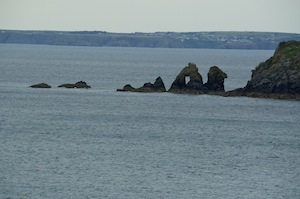
On reaching Little Haven, we met up with Angela, which gave those who had had enough a get out for the last five miles to St Brides. My cockerel had had enough so I detached him from my rucksack for the remainder of the walk. This just left four of us for this final stretch, through more varied terrain. We were again on a stretch of coast sheltered from the westerlies. Here trees grew and we walked for a while through mature, broad-leafed trees. Among them it was hot and humid and we were constantly pestered by flies wishing to drink our sweat. Eventually we emerged onto the fresher treeless cliff path. Out in the bay were some rocks with a natural arch passing through them. They gave the appearance of a sea monster wriggling its way through the water.
Dramatic coastline and waters
The final day saw us walking from St Brides round the peninsula to Martin’s Haven and then along the cliffs above the inaccessible Marloes Sands and then around the peninsula that is St Ann’s Head before finishing at Dale. There was more wind today and the sea on exposed coasts crashed over the rocks on the shore. A few large tankers were anchored off shore awaiting their opportunity to birth at nearby Milford Haven. The chimneys of Milford Haven could be seen for most of the day but despite it being Europe’s largest oil and gas terminal it does not seem to encroach too much on the rest of the beauty of the Pembrokeshire Coast Path. Obviously you cannot avoid seeing it but it did not, as far as we were concerned, detract from the beauty or enjoyment of the walk.
Cobbler’s Hole
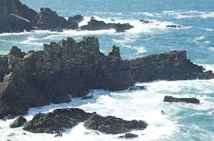
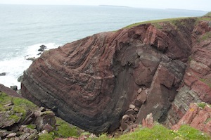
While some of the old lighthouse properties are now abandoned, the lighthouse itself has been turned into residences with outstanding views across the water. Rounding St Anne’s Head we detoured slightly to have a look at Cobbler’s Hole, a small inlet that displays the pressures forced upon rock way back in geological time and how it has been shaped.
We now only had a couple of bays to walk around before heading for Dale Point and then into Dale. There was a Pirate’s party taking place to raise money for children’s play equipment. There was a lively atmosphere, added to which were numerous sailors visiting for the weekend. The bay was littered with anchored yatchs and the Griffin, the pub we veered towards was busy. We sat on a balcony overlooking the activities and enjoyed a few beers in the sunshine.
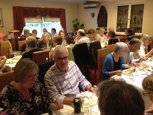
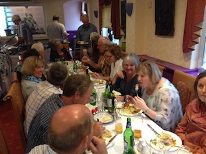
In the evening we returned to the Griffin for a celebratory meal. It was not disappointing at all, but extremely good. We had had a good week with good walking, good weather, good company and good food. What more could you ask for in life? Oh yes, not to rain heavily when we struck camp the next morning!

 Parking at Bewdley station I paid my £3 for all day parking (what a bargain) and headed off down to the river. The early morning sun reflected off the white fronts of the individual houses on the opposite bank.
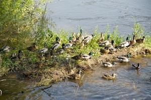
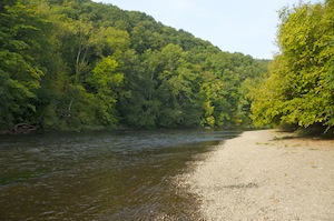 Returning to the river bank much of the early part of the walk is through woodland with occasional stretches of open fields, particularly around Trimpley Reservoirs, hidden behind a raised bank. Dropping down through trees to a shingle beach I was provided with glorious views of the river, glistening in the sunshine downstream and overshadowed by trees in the first throes of autumnal change. Now the water is less sluggish as it tumbles over little clusters of rocks, not big enough to call rapids or waterfalls but just enough to disturb the gentle flow and give a background sound of babbling water. The quacking of ducks sounding more like an over enthusiastic reaction to a joke rang out through the trees to let me know that there was plenty to see on the river. I was keen to see heron and perhaps the flash of colour from a kingfisher, but there were none, certainly on this first stretch of the river.
 After nearly four miles I emerged out of the woodland to Upper Arley, a riverside hamlet of attractively expensive houses and a pub. Here a footbridge took me to the West Bank of the river and from now on the walk was largely across fields with less woodland. I was also now walking parallel with the Severn Valley Railway and ideally positioned for viewing any passing trains. I had heard none so far but as I continued my journey north I began to hear the hoot of a steam engine echoing in the valley. Eventually a sight from my childhood emerged, a classic steam engine pulling carriages over a bridge and along a raised embankment. As it came by heads popped up from the river bank as fishermen were distracted from their hypnotic staring at bobbing floats to watch it pass.
 Much of this stretch of the river between Bewdley and Bridgnorth has restricted fishing for the Birmingham Angling Association. Clearly not satisfied with their miles and miles of canals in Birmingham, they have to invade rural Worcestershire and Shropshire. Do you have to be a resident of Birmingham to be able to join? Judging by the accents I heard it would appear so. They were not a happy bunch. While they were enjoying the warm sunshine, the fish were not biting. Very few had employed their keep nets and I am convinced some had dozed off under the hypnotic bobbing of their floats.
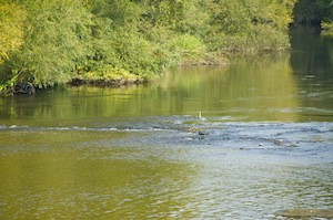 Eventually I saw a heron, and then, having seen one, I saw two more. The first was standing mid river on a sharp bend at one of those points where the water tumbled over a small ridge of stone, hoping to catch small fish caught up in the increased water flow and unable to escape the heron’s darting beak. The second I stumbled upon on my side of the river bank. Startled, it flew off before I could get my camera out. The third, clearly having no more luck than the fishermen, had given up and was standing some distance away in the middle of a field.