Leaving the group behind at the hotel, either asleep or waving me off, I was picked up by minibus at 7.00am and taken to the main Grey Line bus station. There, I transferred to another minibus and waited for Lars, Charlotte and their two children from Sweden, my fellow travellers for the day, to arrive. All assembled we set off with me sitting up front while my Swedish companions spread out in the back. Our driver seemed very fidgety to begin with and was trying to do several things at once, which distracted him from his driving, to the extent that on a sweeping curve we mounted the kerb and ran over the grass verge. This seemed to have the desired effect and from then on he concentrated on his driving. It was not a very encouraging start. We chatted on and off throughout the journey and I discovered that he had five children, three of whom were living and working, or studying in Berlin. The other two would leave Iceland as soon as they had finished their schooling. This highlights a real problem that Iceland is facing, the desertion by its young talent for more vibrant and opportunistic cities. All the traditional industries of Iceland are dwindling. Since the crash of 2008 many professional opportunities have gone and there does not appear to be a very optimistic future for the next generation. Tourism is bucking that trend and is a success story. It is now bigger than any other industry and is set to grow further. I hope so, because an awful lot of money is being invested in the building of new hotels etc. Not everybody wants to be a servant to tourists and so they feel they have to leave. Like the rest of Western Europe, East Europeans are filling the jobs that Icelanders don’t want to do.
This filled the time and we arrived at the small, but busy, quayside at Landeyjahöfn, at the mouth of the Markarfljot River, soon after 9.00am. As we turned off the main road to the quay, Seljalandsfoss could be seen to our left. Our driver sorted the tickets for us and we boarded the ferry, Herjolfur, for the thirty five minute trip across to the main island, Heimaey. Nearly everybody chose to travel on deck to enjoy the view. The sea was calm, the sun was shining. Than was no reason to hide away. As we left the quayside the propellers churned up mud from the seabed which attracted numerous noisy Arctic Terns that dived into the churning water to catch morsels that had been disturbed.

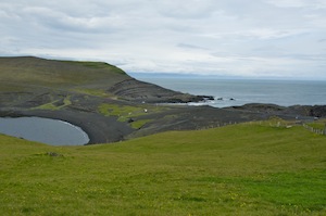
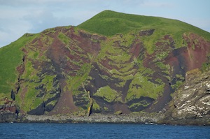
The islands of Ellidaey and Bjarnarey
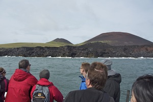
Beyond the breakwaters we rocked gently as we ploughed our course across the short stretch of water to the largest of the islands. To our left, or should I say port side, two islands rose vertically out of the sea, with towering cliffs providing plenty of nesting opportunities for colonies of sea birds that left white streaks trailing from their perches. On both of the islands there is a single house, although nobody actually lives on them. They are, maybe summer residences, although I don’t know how they gain access to the islands as they seem to have precipitous cliffs all around them.
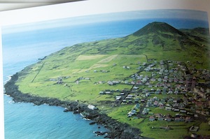
Heimaey before the 1973 eruption, taken from a book. Helgafell is on the right, Eldfell is now in the middle of the flat farmland to the left.
In January 1973 the island of Heimaey suddenly erupted forcing all of the island’s 5200 inhabitants to evacuate. For many years the people, the bulk of whom lived in the town surrounding the busy fishing harbour, had lived in the shadow of Helgafell, a perfect cone-shaped volcano. But this was a new vent. Had there not been a severe storm in the days leading up to the eruption, the fishing fleet would all have been at sea. As it was, they were all in port and were able to evacuate everybody to the mainland, and safety. The eruption continued for five months, spewing out over 30 million tons of lava, destroying one third of the town (360 houses), increasing the size of the island by 2.5 sq. km. When the lava flows threatened to close off the harbour, firefighters hosed it down with cold sea water, stemming, and eventually halting the flow. Had they not done so and the harbour entrance closed there would have been little reason for people to return. Remarkably the eruption and the intervention of the fire service resulted in a much more sheltered harbour with a long narrow entrance between high cliffs and new land. When things had calmed down, two-thirds of the population returned to rebuild their lives.
Helgafell on the left, Eldfell on the right
The outcome of five months of eruption was a new volcano, the 205m Eldfell. It was originally 240m but it contracted as it cooled, although it is still far from being cool.
I remember seeing images on the news of houses being engulfed under a wall of creeping black. I also remember images from ten years previously when Surtsey, another of the Westman Islands, emerged from the sea in a dramatic under-the-ocean eruption. On the news this week it was reported that Surtsey is warming up and threatening to erupt again in the not too distant future.
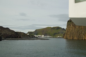
Entering the narrow harbour
As we turned in towards the harbour it was hard to believe that it was not only wide enough but also deep enough for a vessel like the Herjolfur. On the starboard side brown/orange cliffs towered above us while on the port side black 42 year old lava seemed to get closer and closer.
Having docked we disembarked and headed straight to the jetty from which I was to take the round the island boat trip. Unfortunately, the boat was going nowhere. There was a fault wit the engine and it was going to take a while to repair. The sun was shining and it was pleasantly warm so I did not mind too much. Things looked bad when a man with very oily hands came along the jetty carrying several pieces of cast steel that should have been one piece. He sped off in his car, returning a few minutes later with a replacement part that was quickly put where it should be. A few minutes later the engine spluttered into life and we were, apologetically, welcomed aboard forty minutes later than scheduled.
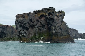
Black lava tumbling into the sea
Leaving the harbour, we travelled clockwise around the island. This took us immediately to the side of the island that was facing the incoming wind, so, being a relatively small vessel we bobbed about a bit. Looking at the island we were looking at the new land. It was jet black and devoid of any vegetation. It tumbled over itself in liquid folds until it fell into the sea, creating a stark contrast with its white froth caused by it crashing into the lava, sending spray up into every reachable nook and cranny. A black column rose up from the sea, detached from the island, standing like a sentinel on guard.
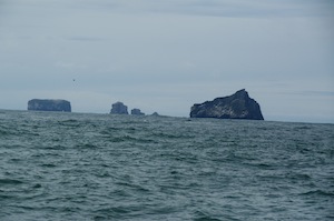
Volcanic islands trail south from Heimaey
As we cleared the new coastline the colour of the cliffs became more traditional with wave and wind smoothed features creating caves, arches and stacks. Out to the south more sentinel islands rose vertically out of the sea in dramatic fashion. They were stunningly beautiful and changed with each turn of the rudder. Furthest south stood the baby of them all, Surtsey with a mixture of dramatic cliffs and a tail drifting off into the sea.
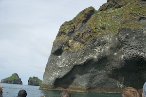
A large elephant dipping his trunk into the sea
Travelling up the west side of Heimaey we were sheltered from the prevailing wind. If anything, the coastline was even more dramatic this side with towering cliffs colonised by thousands of noisy sea birds. We entered colourful caves, wary of the birds above as we entered. Seals basked on rocks. The rocks now took on other features as they displayed huge volcanic upheaval with basaltic columns twisted and contorted into fantastic shapes, rose heads and spirals. To the side of one cave we entered was the largest elephant in the world, its head clearly seen with eye and its huge trunk disappearing into the sea below. Such natural beauty and drama far surpasses anything man can produce on such a scale, and it too such violence to create it.
On the north coast we hit the fish processing plant. Having been in awe at such grandeur, we now cringed by the smell that came from it. While we cringed, sea birds gathered in their hundreds, attracted by the smell and the opportunity for an easy meal.
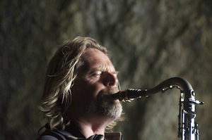
Viking saxophonist
Soon clear, we rounded the headland and headed towards the harbour. Hugging the cliffs, we entered one last cave where the engines were cut and the captain played his saxophone. Acoustically it was superb and everybody on the boat was mesmerised by this unexpected treat. Having applauded him, the engines were fired up and we exited the cave to find the ferry baring down on us, overtaking us and beating us into the harbour. It struck me how fast it was going in such a narrow channel of water and of what confidence they must have in the ship and themselves.
It had taken us an hour and a half to travel round the island and it was now lunch time. After such an early start and no breakfast I was ready for it. Our guide took us to Gott Restaurant in the centre of town for lobster soup and bread. It was a busy, vibrant place with as many locals there as tourists, which is always a good sign. The soup was delicious.
The delayed departure of the boat in the morning put us behind schedule so the coach trip round the island compensated and delayed its departure. Our guide arranged for the coach to pick up up from the restaurant, ensuring we were not rushed. By the time the coach picked us up it was already half full of ageing tourists, mostly American. They were all enthusiastically seated in the front half, leaving me free to spread out near the back. There were no more pick ups so I was able to enjoy the space and not have to indulge in any conversation. I don’t normally cherish the thought of a coach trip but it was a quick visit and I wanted to make the most of the opportunity to see as much as I could and not waste time trying to find it for myself.
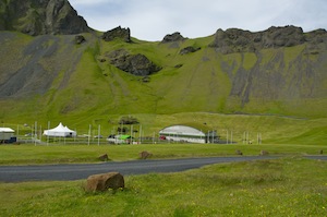
The community ground in a huge natural amphitheatre
Leaving the town we went to the community ground, passing the football ground where a junior tournament was taking place and adjacent to the golf course. For such a small place and a population of less than 5000, Heimaey has everything. The community ground is the site of an annual festival held during the first weekend in August, in fact, next weekend. Teams of people in high vis vests were busy making ready for the huge numbers that attend, approximately 15,000, who enjoy lots of music from the festival stage, dancing, gallons of alcohol, fireworks and a huge bonfire. The site is a huge natural amphitheatre rising steeply to the cliff top.
Our driver/guide talked constantly switching between Icelandic and English with ease. He was local and talked with passion about his heritage. He experienced, as a child, the 1973 eruption and was able to give a graphic description of what it was like before he was evacuated to Skogar on the mainland.
A narrow isthmus separating two craters
Heading south we stopped at various places of interest and were given time to wander around. Towards the south there is a narrow neck of land where two underwater craters almost meet. At the most southern end of the island (it is only 7km long) is the official windiest place in Europe, although today it relatively calm. Nearby was a puffin colony but, having recently been to Skomer, this was a disappointment. Heading back towards the town we passed between the two volcanos of Helgafell and Eldfell before ending up at the museum marking the 1973 eruption. I wanted to leave myself enough time to climb Eldfell, so I quickly went through the museum, which was interesting and probably deserved more time spent there than I was prepared to give. There was the remains of a house, plenty of film and lots of first hand accounts and personal stories.
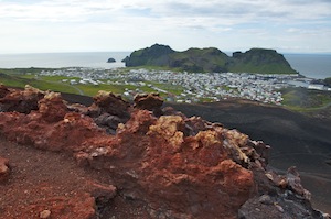
Looking down on Heimaey from Eldfell
Leaving the museum, I headed for Eldfell. A Redshank standing, unperturbed by me, on a road sign distracted me briefly from my mission. Leaving the road, I took the track to the hill. At 205m it does not qualify to be anything other than a hill. However, it was steep and the path was made up of fine volcanic ash, making it more of a challenge. The rim of the crater is on the south and east side, with virtually no rim to the north and west. This was the direction that all the lava and ash spewed, engulfing the town and threatening the port. The rim is made up of red cinder. In places there are small vents emanating heat. No smoke or steam is apparent but the rocks and the air in the vent is still hot to touch and feel. From the summit you could see the full extent of its effect as well as the whole of the rest of the island. The island can be roughly divided into four quarters. The town accounts for a significant proportion, the small airport with its two runways accounts for much of the central portion, the new volcano and its lava flows another significant section and the southern tip beyond the two bays the fourth quarter.
Where the street once was but now buried under 20m of lava
Descending by a different route, I came to the area where the lava flow encroached on the town. Signs stuck into the ground show the street names where they used to be but are now under 20m of lava, hidden for ever. Walking through the suburbs of the town it was clear that this is a relatively prosperous place. The houses were quite large, well appointed and cared for, unlike some other rural areas of mainland Iceland. Of course Heimaey has a lot in its favour. It is small, it has a very successful and prosperous fishing industry and it is very much on the tourist trail.
Light illuminating the side of an old crater on Bjarnarey
Back at the port the Herjolfur was waiting to return me to the mainland and then the minibus journey back to Reykjavik, getting back soon after 9.00pm. The driver took me to Hotel Cabin to collect my luggage and the helpfully took me to the Kex Hostel on Skulagata. The front of the building and the entrance is not encouraging but once inside the former biscuit factory it becomes a vibrant, lively and fascinating place serving good food and beer. What more could I ask for after a good day on Heimaey?
